AEMET Issues Weather Alert: Large Hail and Heavy Rain Forecast
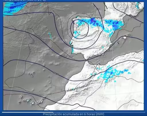
Spain’s national weather agency, AEMET, has issued a special warning as a DANA, a high-level isolated depression, moves in from the west and brings severe thunderstorms, large hail, heavy downpours, and strong winds to several regions of the country over the coming days.
Unsettled Weather Begins Friday
The worst of the weather is expected to start on Friday, July 11, as the DANA pushes in from the northwest and destabilises the atmosphere, especially in the northern and eastern parts of the peninsula. According to AEMET, storms could be particularly intense across areas like the eastern Cantabrian coast, Navarra, La Rioja, and Aragón.
These areas are at risk of hailstones larger than 2 cm, very strong gusts of wind, and rainfall totals of up to 30–40 litres per square metre in just one hour. Storms will likely develop in the afternoon around the Cantabrian Mountains and the Iberian System, before moving north and northeast.
Heavy showers may also hit parts of northern Castilla y León, Asturias, and the Pyrenees. AEMET warns that storms could stall or regenerate in some areas, leading to persistent downpours and significant accumulations of rain.
Storm Risk Shifts to the Northeast on Saturday
By Saturday, July 12, the DANA is forecast to move east across the northern half of Spain, shifting the focus of the most intense weather to the northeast, especially Aragón and Cataluña. Both regions are expected to see another day of unsettled and potentially dangerous conditions.
Elsewhere, storms could also pop up more locally in parts of the Valencian Community, Navarra, La Rioja, eastern Castilla y León, and along the eastern Cantabrian coast. The Balearic Islands could also be affected, though with less intensity.
⛈️El paso de una dana por el norte peninsular junto con la llegada de aire húmedo desde el Mediterráno van a favorecer la formación de tormentas muy fuertes desde esta tarde de jueves hasta el sábado.
— AEMET (@AEMET_Esp) July 10, 2025
→ La zona más afectada será el nordeste peninsular. Seguiremos informando. pic.twitter.com/VLs3VzegMB
Cooler Air and Lower Temperatures
The arrival of a cooler air mass, along with increased cloud cover, will bring a noticeable drop in temperatures, especially on Saturday. Cities across much of Spain are expected to see highs below 30°C, even in traditionally hot areas like Sevilla, where the daytime temperature will likely stay under 30°C and nighttime lows could fall below 20°C.
According to weather experts, this weekend will feel much cooler compared to the last, when some areas topped 40°C. They added that ‘tropical nights’ (when temperatures stay above 20°C) will mostly disappear, except along the Mediterranean coast and in the Canary Islands.
Weather Calms on Sunday Before Heat Returns
By Sunday, July 13, the DANA is expected to move away from the peninsula, making room for a ridge of high pressure from the Atlantic to settle in. This will bring more stable conditions and gradually rising temperatures, especially in central and southern regions, where highs are expected to climb back above 35°C.
‘Canícula’ Set to Start Next Week
Looking ahead, temperatures will continue to rise into the new week, just as Spain enters the canícula, the traditional peak of summer heat, beginning July 15. For now, no temperatures above 40°C are expected early in the week, at least through to Wednesday.
Share this content:


1 comment